
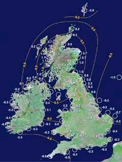
THE banks of the River Severn have been steadily sinking at the rate of 0.3mm a year since the end of the last ice age according to the latest research.
With the last ice age ending 20,000 years ago, this means the Forest's estuary shores could have subsided by a grand total of six metres.
The figures are revealed in the latest research by Durham University into the way the country has tilted following the melting of the ice sheets.
"You have to think of it like the land relaxing after being kept under an enormous weight of ice," said Professor Ian Shennan who led the Durham research. "When a huge mass of ice melts, the land readjusts over time. The rate of uplift north of the River Tyne to Scotland increases because the ice sheets there were thicker and heavier"




As Scotland rises, so the south of England, Bristol Channel, Gwent Levels and East Anglia, tend to subside, which has implications for anyone involved in working on estuary defences or flooding schemes.
The 'tilt' figures were calculated by taking core samples of sediment, peat and sand from more than 80 sites around the UK, including the Severn Estuary and Gwent Levels. The sediment samples were radio-carbon dated to see how they'd formed and to calculate changes in sea levels.
The rate of sinking is lower than Durham's previous projections published in 2002, because the team are now working with a more detailed database.
But they only measure the 'tilt', not the projected rise in sea levels as a result of global warming.
"To get an estimate of how much water levels are rising," said Prof Shennan, "You'd need to combine our figure of 0.3mm subsidence a year, with the projected rise in sea levels of about 1.5mm a year – which adds up to 1.8mm a year."
On that basis, if you do the maths, sea levels in the estuary will rise by 36mm over the next 20 years – just over a foot, or 14ins.
Comments
This article has no comments yet. Be the first to leave a comment.